


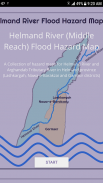
Helmand River (Middle Reach) Flood Hazard Map
Opis aplikacije Helmand River (Middle Reach) Flood Hazard Map
Rivers give life, connect and shape societies and have a high influence on civilization. Living along the riversides is the enjoyment of nature, but river floods usually face societies to extreme damages. Thus, adequate information about behavior and flood of the rivers is a must for adapting and land use planning in such hazard-prone zones.
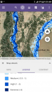
Helmand River Flood Hazard Map provides a comprehensive overview of the riverine flood hazards along the banks of Helmand and Arghandab Tributary River inside Helmand province that threaten the area currently, as well as how these hazards are likely to increase in the future. And tells you a bunch of key information obtained by hydrological and hydraulic calculations with floods of different return periods (e.g. 2-year, 5-year, 10-year, 25-year, 50-year, and 100-year). The data is presented in the format as:
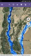
1. Flood Inundation Boundary for different return periods of floods.
2. Flood Hazard in terms of Inundation Depth.
3. Flood Hazard in terms of Depth x Velocity.
The information provided in this app is intended to enable more informed decision-making by residents, property, and business owners, farmers, engineers, and policymakers.
Helmand River (Middle Reach) Flood Hazard Map - Verzija 1.0.2
(07-11-2020)Helmand River (Middle Reach) Flood Hazard Map - Informacije o APK datoteci
Verzija APK datoteke: 1.0.2Paket: com.HelmandRiver.FloodMapsApp


Aplikacije u istoj kategoriji


Možda će vam se takođe dopasti i...


